Special | A | B | C | D | E | F | G | H | I | J | K | L | M | N | O | P | Q | R | S | T | U | V | W | X | Y | Z | ALL
S |
|---|
Sea levelThe height of the sea at a given time measured relative to some datum, such as mean sea level. | |


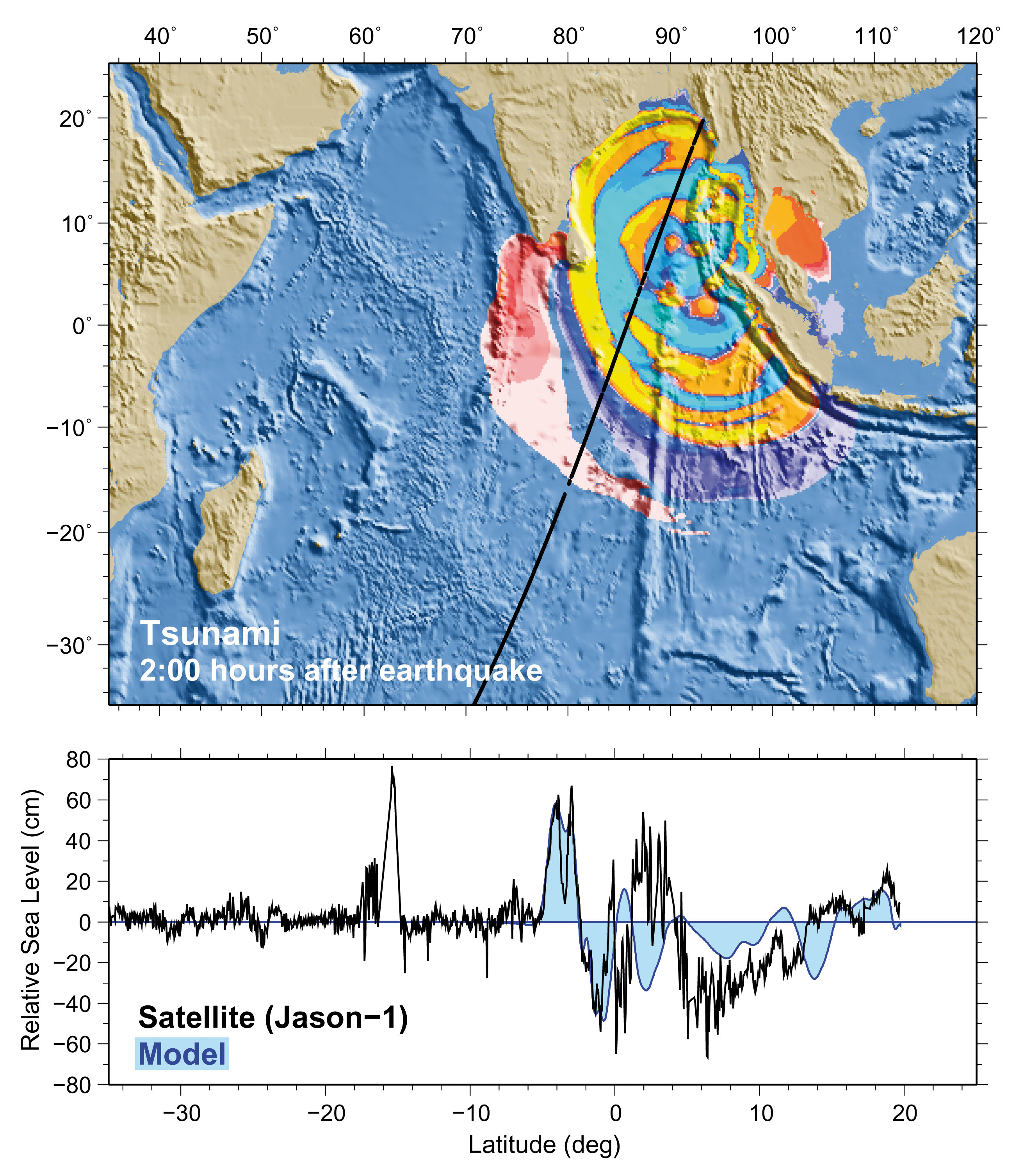
Sea Surface HeightSatellite altimeters monitor Sea Surface Height (SSH), and can record a snapshot of the propagating tsunami if the satellite orbit is located above the tsunami. During the 2004 Indian Ocean tsunami and 2011 Tohoku tsunami, several satellites captured the tsunami as it propagated across the Indian and Pacific Ocean, respectively.
Radar altimeters aboard the Jason-1 satellite recorded the 26 December 2004 Indian Ocean tsunami in a snapshot taken two hours after the earthquake. Bottom profile superimposing MOST model calculations on the satellite data shows a maximum wave amplitude of about 60 cm. Image courtesy of NOAA. | |

SeicheA seiche may be initiated by a standing wave oscillating in a partially or fully enclosed body of water. It may be initiated by long period seismic waves (an earthquake), wind and water waves, or a tsunami. | |
Seismic sea waveTsunamis are sometimes referred to as seismic sea waves because they are most often generated by earthquakes. | |
Sieberg tsunami intensity scaleA descriptive tsunami intensity scale, which was later modified into the modified Sieberg sea-wave intensity scale (Ambraseys, 1962). | |
Significant wave heightThe average height of the one-third highest waves of a given wave group. Note that the composition of the highest waves depends upon the extent to which the lower waves are considered. In wave record analysis, the average height of the highest one-third of a selected number of waves, this number being determined by dividing the time of record by the significant period. Also called characteristic wave height. | |
SpreadingWhen referring to tsunami waves, it is the spreading of the wave energy over a wider geographical area as the waves propagate away from the source region. The reason for this geographical spreading and reduction of wave energy with distance travelled, is the sphericity of the earth. The tsunami energy will begin converging again at a distance of 90 degrees from the source. Tsunami waves propagating across a large ocean undergo other changes in configuration primarily due to refraction, but geographical spreading is also very important depending upon the orientation, dimensions, and geometry of the tsunami source. | |
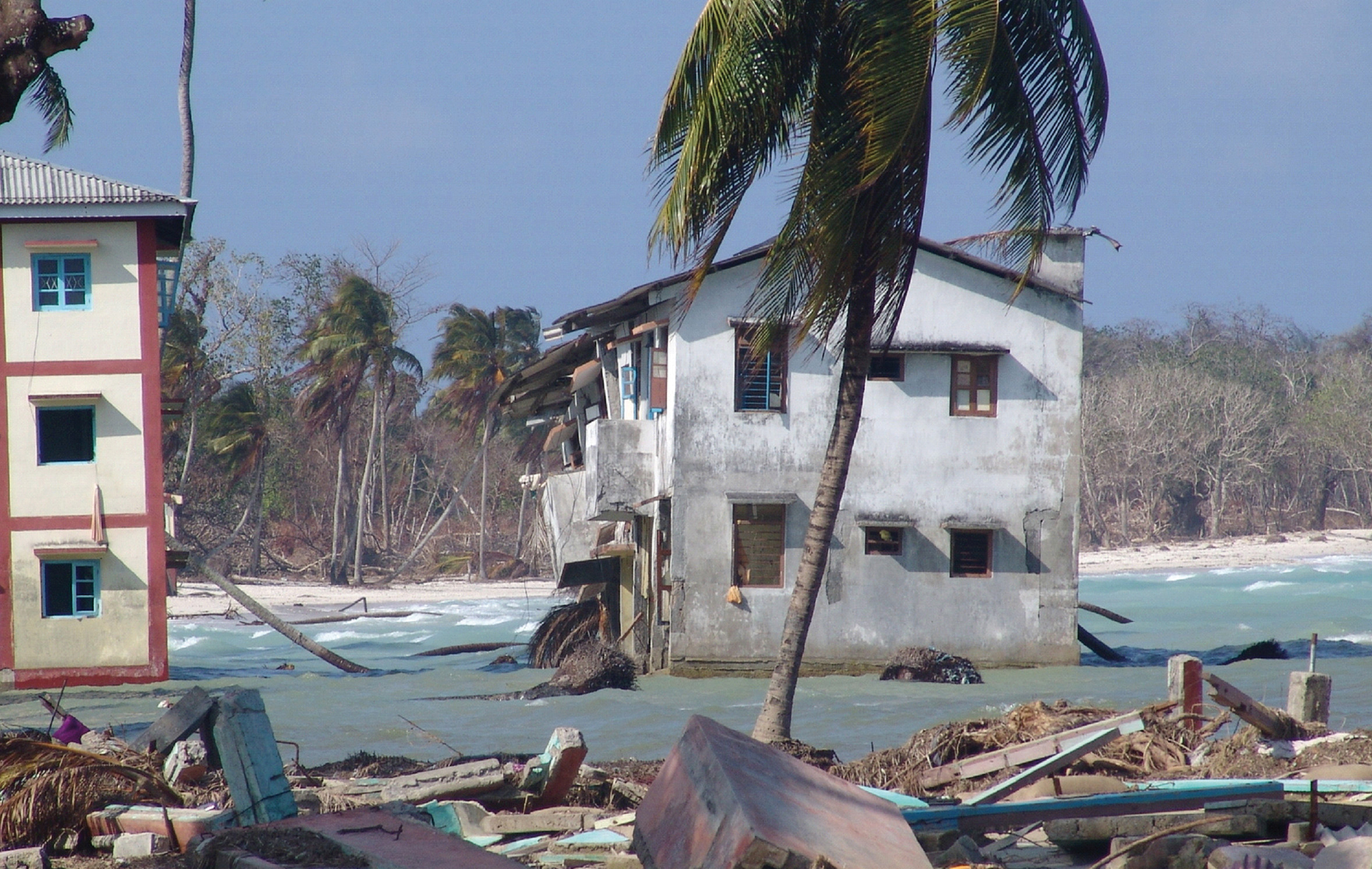
Subsidence (uplift)The permanent movement of land down (subsidence) or up (uplift) due to geologic processes, such as during an earthquake.
The 26 December 2004 earthquake resulted in 1.2 m of land subsidence in the Car Nicobar, Nicobar Islands, India, leaving houses that were once above sea level now permanently submerged. Photo courtesy of ICMAM, Chennai, DOD, India. | |