Special | A | B | C | D | E | F | G | H | I | J | K | L | M | N | O | P | Q | R | S | T | U | V | W | X | Y | Z | ALL
T |
|---|
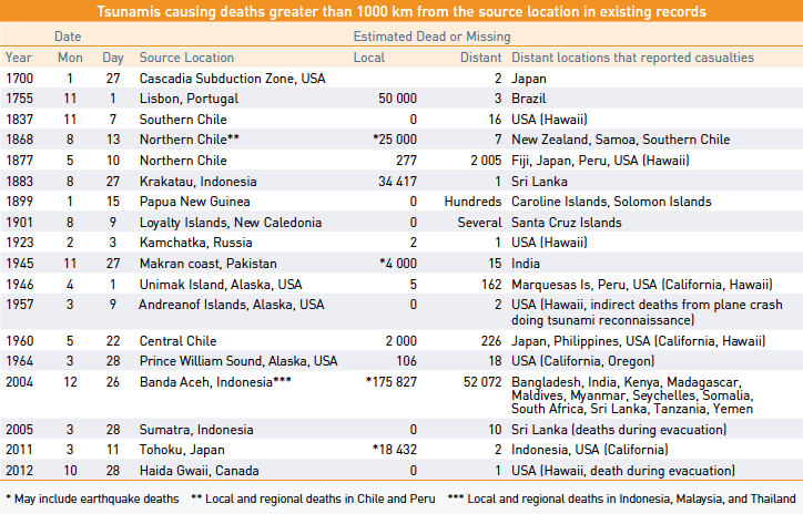
Teletsunami or Distant TsunamiA tsunami originating from a far away source, generally more than 1,000 km or more than 3 hours tsunami travel time from its source. Less frequent, but more hazardous than regional tsunamis, are ocean-wide or distant tsunamis. Usually starting as a local tsunami that causes extensive destruction near the source, these waves continue to travel across an entire ocean basin with sufficient energy to cause additional casualties and destruction on shores more than a 1,000 kilometres from the source. In the last 300 years, there have been at least 43 destructive oceanwide tsunamis and 18 have caused fatalities. The most destructive Pacific-wide tsunami of recent history was generated by a massive earthquake off the coast of Chile on 22 May 1960. All Chilean coastal towns between the 36th and 44th parallels were either destroyed or heavily damaged by the action of the tsunami and the earthquake. The combined tsunami and earthquake toll included 2,000 killed, 3,000 injured, two million homeless, and $550 million damage. Off the coast of Corral, Chile, the waves were estimated to be 20 metres (67 feet) high. The tsunami caused 61 deaths in Hawaii, 20 in the Philippines, and 139 in Japan. Estimated damages were $50 million in Japan, $24 million in Hawaii and several millions of dollars along the west coast of the United States and Canada. Distant wave heights varied from slight oscillations in some areas to 12 metres (40 feet) at Pitcairn Island, 11 metres (37 feet) at Hilo, Hawaii, and 6 metres (20 feet) at some places in Japan. The worst tsunami catastrophe in history occurred in the Indian Ocean on 26 December 2004, when a M9.3 earthquake off of the northwest coast of Sumatra, Indonesia, produced an ocean-wide tsunami that hit Thailand and Malaysia to the east, and Sri Lanka, India, the Maldives, and Africa to the west as it traversed across the Indian Ocean. Nearly 228,000 people lost their lives and more than a million people were displaced, losing their homes, property, and their livelihoods. The magnitude of death and destructiveness caused immediate response by the world’s leaders and led to the development of the Indian Ocean Tsunami Warning and Mitigation System in 2005. The event also raised awareness of tsunami hazards globally, and new systems were established in the Caribbean, the Mediterranean and Atlantic.
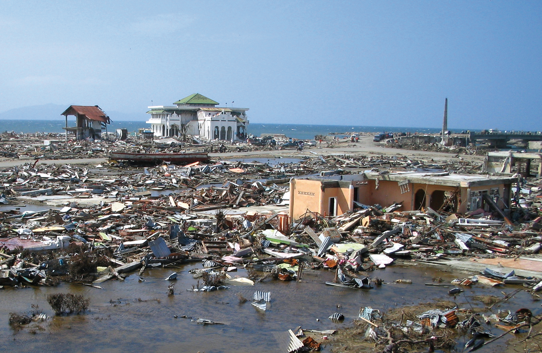
The tsunami of 26 December 2004 destroyed the nearby city of Bandas Aceh, Indonesia, leaving only a few structures standing. Photo courtesy of Yuichi Nishimura, Hokkaido University. | |
TERtaken to ensure public safety by responsible agencies after notification by the Tsunami Warning Focal Point (TWFP), typically the national Tsunami Warning Centre. It includes Standard Operating Procedures and Protocols for emergency response and action, organizations and individuals involved and their roles and responsibilities, contact information, timeline and urgency assigned to action, and means by which both ordinary citizens and special needs populations (physically or mentally handicapped, elderly, transient, and marine populations) will be alerted. For tsunami response, emphasis is placed on the rapidness, efficiency, conciseness, and clarity of the actions and instructions to the public. A Tsunami Emergency Response Plan should also include post- tsunami actions and responsibilities for search and rescue, relief, rehabilitation, and recovery.
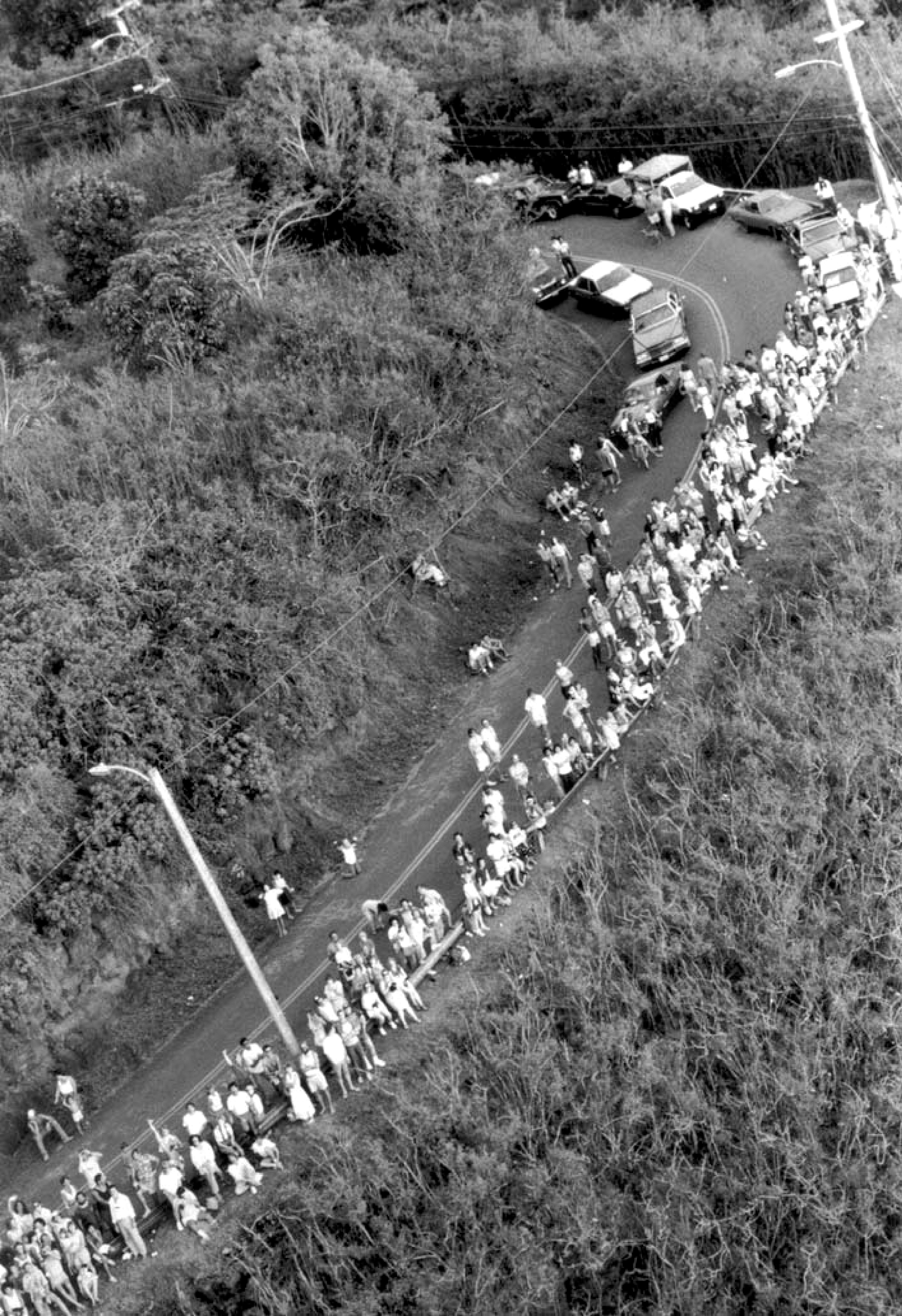
PTWC issued a tsunami warning in 1986 for an Aleutian Islands earthquake, prompting Hawaii emergency officials to evacuate all low-lying coasts. Waimea Bay, Oahu, Hawaii. Photo courtesy of Honolulu Star-Bulletin. | |
TICInformation a resource for the development, publication, and distribution of tsunami education and preparedness materials and information on tsunami occurrences, and may support risk assessment and mitigation activities. A Tsunami Information Centre has been established in each of the regional tsunami warning systems within the ICG framework.
| |
Tidal wave
| |
TideThe rhythmic, alternate rise and fall of the surface (or water level)
of the ocean,
and of bodies
of water connected with the ocean such as estuaries
and gulfs, occurring twice a day over most of the Earth and resulting from the gravitational attraction of the moon
(and, in lesser
degrees, of the sun) acting unequally on different parts
of the rotating Earth. | |
Tide amplitudeOne-half of the difference in height between
consecutive high water
and low water;
hence, half of the tidal
range. | |
Tide gaugeA device for measuring the change in sea level relative to a datum. | |
Tide stationA place where tide
observations are obtained.  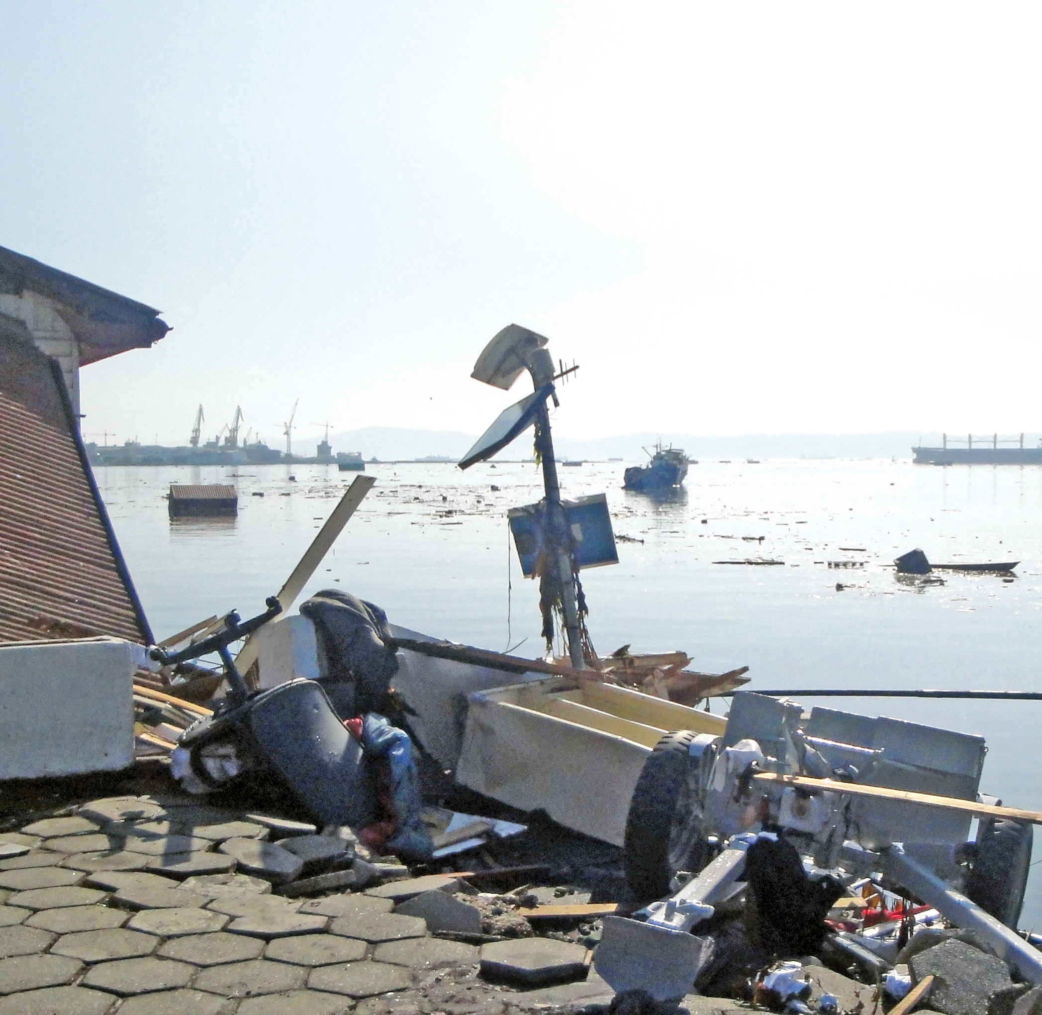 Tsunamis will damage all coastal facilities. This sea level gauge at Talcahuano was being used by the Chilean Navy to monitor the 27 February 2010 Chile tsunami. During the 11 March 2011 Japan tsunami, seven stations were destroyed or damaged and six stations stopped transmitting data leaving JMA unable to fully monitor the tsunami’s severity. Photo courtesy of R. Núñez Gundlach. | |
TNCmitigation system programme. The person may be the Tsunami Warning Focal Point from the national disaster management organization, from a technical or scientific institution, or from another agency with tsunami warning and mitigation responsibilities. | |