Special | A | B | C | D | E | F | G | H | I | J | K | L | M | N | O | P | Q | R | S | T | U | V | W | X | Y | Z | ALL
A |
|---|
Arrival timeTime of the first maximum of the tsunami waves. | |
B |
|---|
BreakwaterAn offshore or onshore structure, such as a wall, water gate, or other in-water wave-dissipating object that is used to protect a harbour or beach from the force of waves.
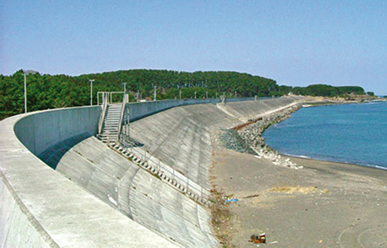
Sea wall with stairway evacuation route used to protect a coastal town against tsunami inundation in Japan. Photo courtesy of River Bureau, Ministry of Land, Infrastructure and Transport, Japan.
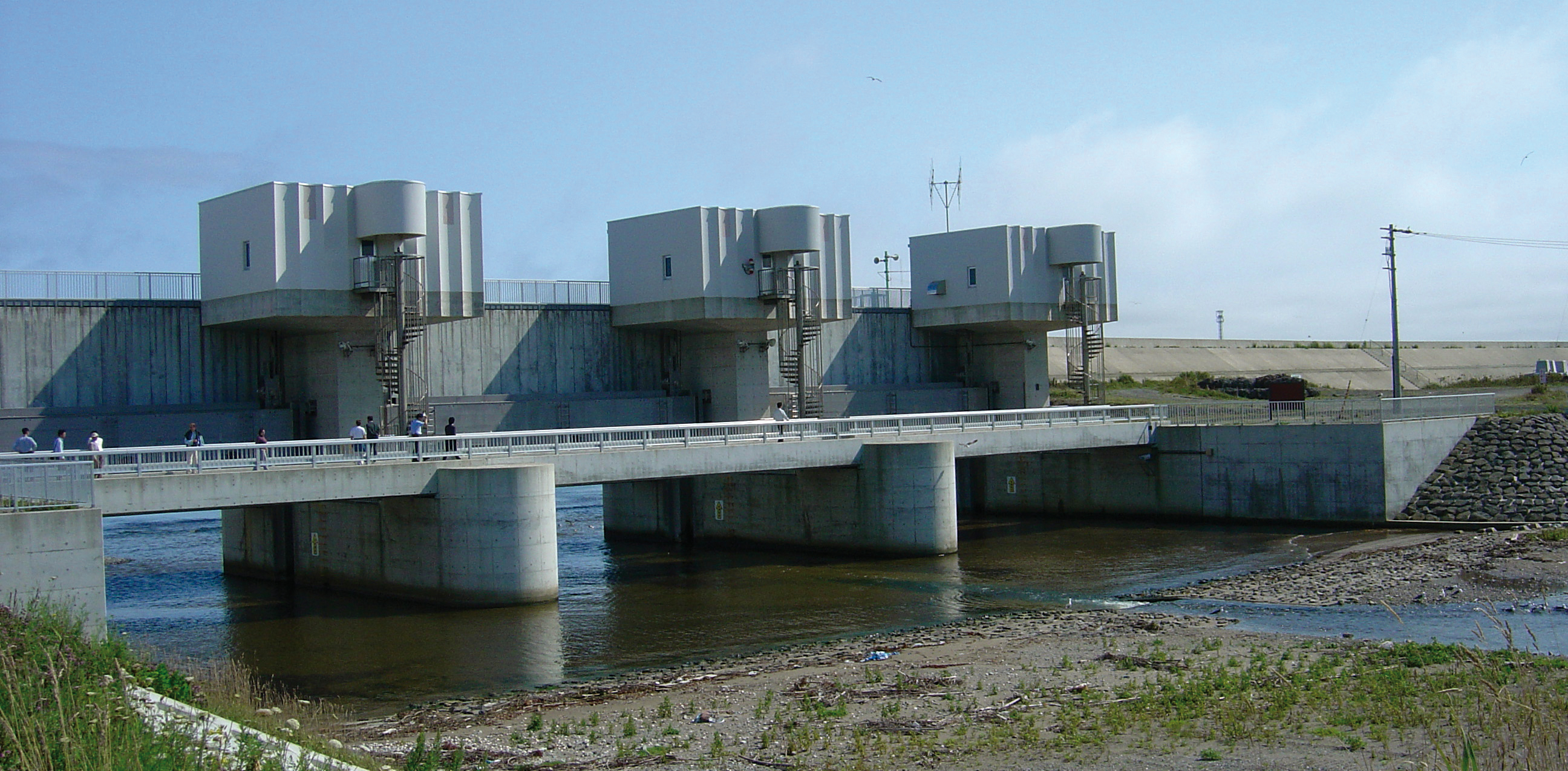
Water gate used to protect against tsunami waves on Okushiri Island, Japan. The gate begins to automatically close within seconds after earthquake shaking triggers its seismic sensors. Photo courtesy of ITIC. | |
C |
|---|
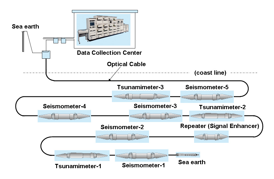
Cabled ocean bottom instrumentAn instrument at the ocean bottom connected to the land by a cable that provides power for the measurement and transmission of data from the seafloor to the coast. Cables can extend for tens of kilometres offshore and across oceans. They enable real-time, multi-sensor seafloor observatories to be deployed for long-term monitoring. Examples of sensors on cabled systems are seismometers to measure earthquakes, sensitive pressure gauges to measure tsunamis, geodetic sensors to measure seafloor deformation, and cameras. Japan operates several cable bottom pressure recording system capable of detecting tsunamison the order of centimetres, and a moored surface buoy for real-time communications. An acoustic link is used to transmit data from the seafloor to the surface buoy. The data are then relayed via a satellite link to ground stations, where signals are demodulated, for immediate dissemination to the NOAA tsunami warnings centres. The DART® data, along with state-of-the-art numerical modelling capabilities, are part of a tsunami forecasting system package that provides predictions of tsunami impact along site-specific coasts.
| |
CotidalIndicating equality with the tides or a coincidence with the time of high or low tide. | |
Crest lengthThe length of a wave along its crest. Sometimes called crest width. | |
D |
|---|
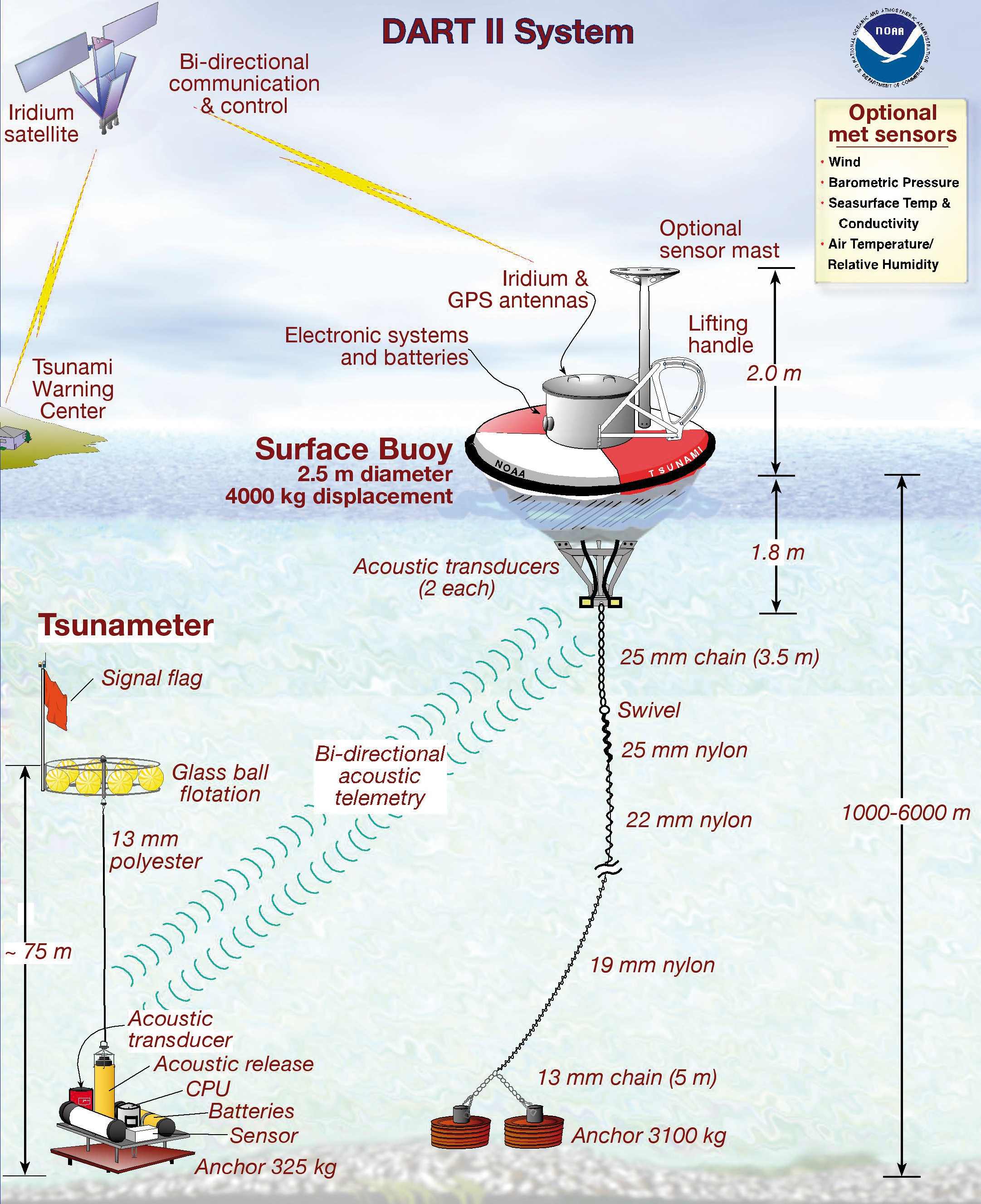
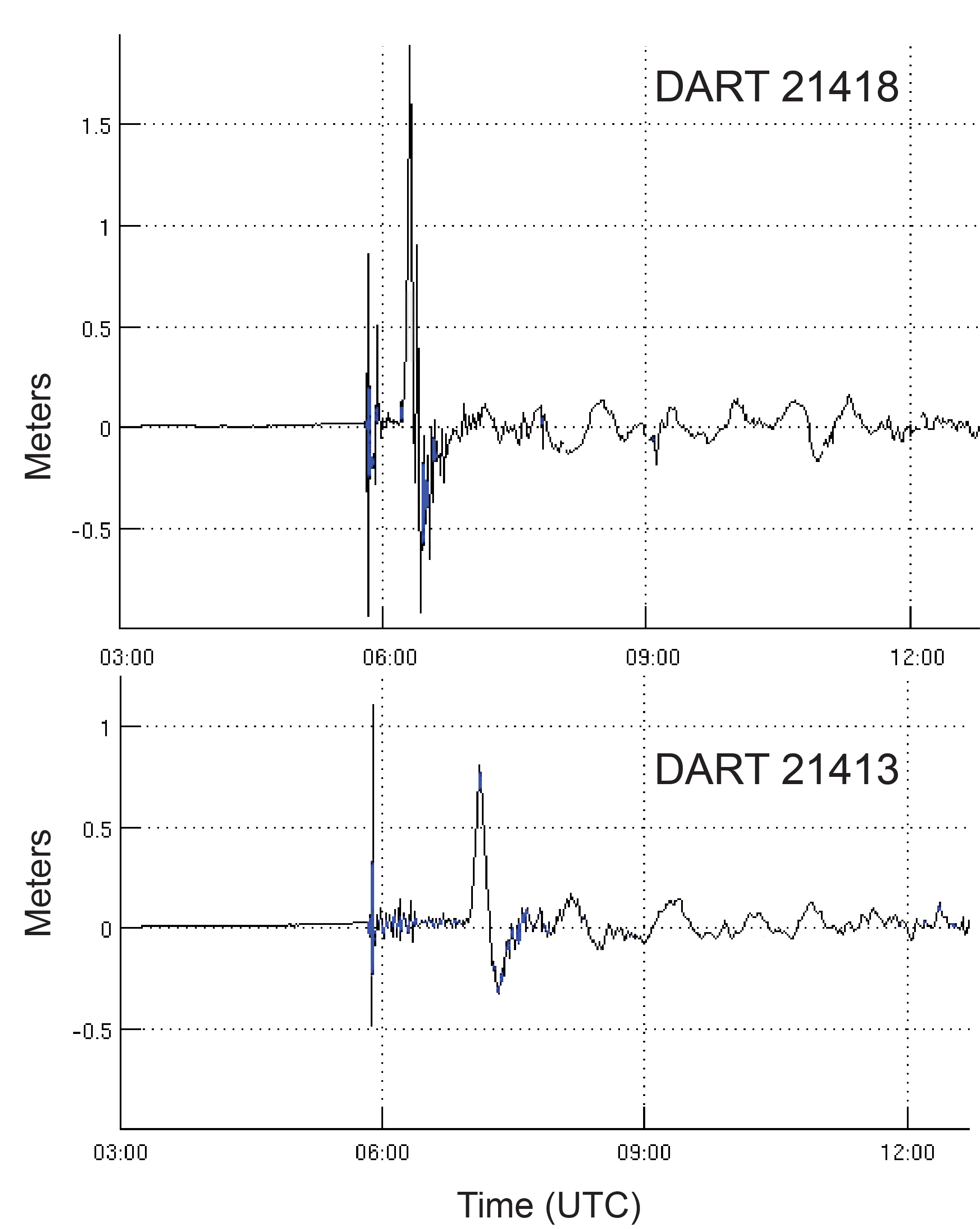
DART®Deep-ocean Assessment
and Reporting of Tsunamis.The DART is an example of a
Tsunameter. An integrated system of hardware and software instrument for the early detection, measurement, and real-time
reporting of tsunamis in the open ocean. Developed by the US NOAA Pacific Marine Environmental Laboratory, the DART® system consists of a seafloor bottom pressure recording system capable of detecting tsunamison the order of centimetres, and a moored surface buoy for real-time communications. An acoustic link is used to transmit data from the seafloor to the surface buoy. The data are then relayed via a satellite link to ground stations, where signals are demodulated, for immediate dissemination to the NOAA tsunami warnings centres. The DART® data, along with state-of-the-art numerical modelling capabilities, are part of a tsunami forecasting system package that provides predictions of tsunami impact along site-specific coasts.
DART® II. Courtesy of NOAA.
The 11 March 2011 tsunami recorded on DART® #21418 located 450 nautical miles northeast of Tokyo. The maximum wave amplitude was 1.8 m measured at 33 min after the earthquake. The 1st arrival on the record is from the earthquake shaking. Data courtesy of NOAA. | |
DropThe downward change or depression in sea level associated with a tsunami, a tide, or some long-term climatic effect. | |
E |
|---|
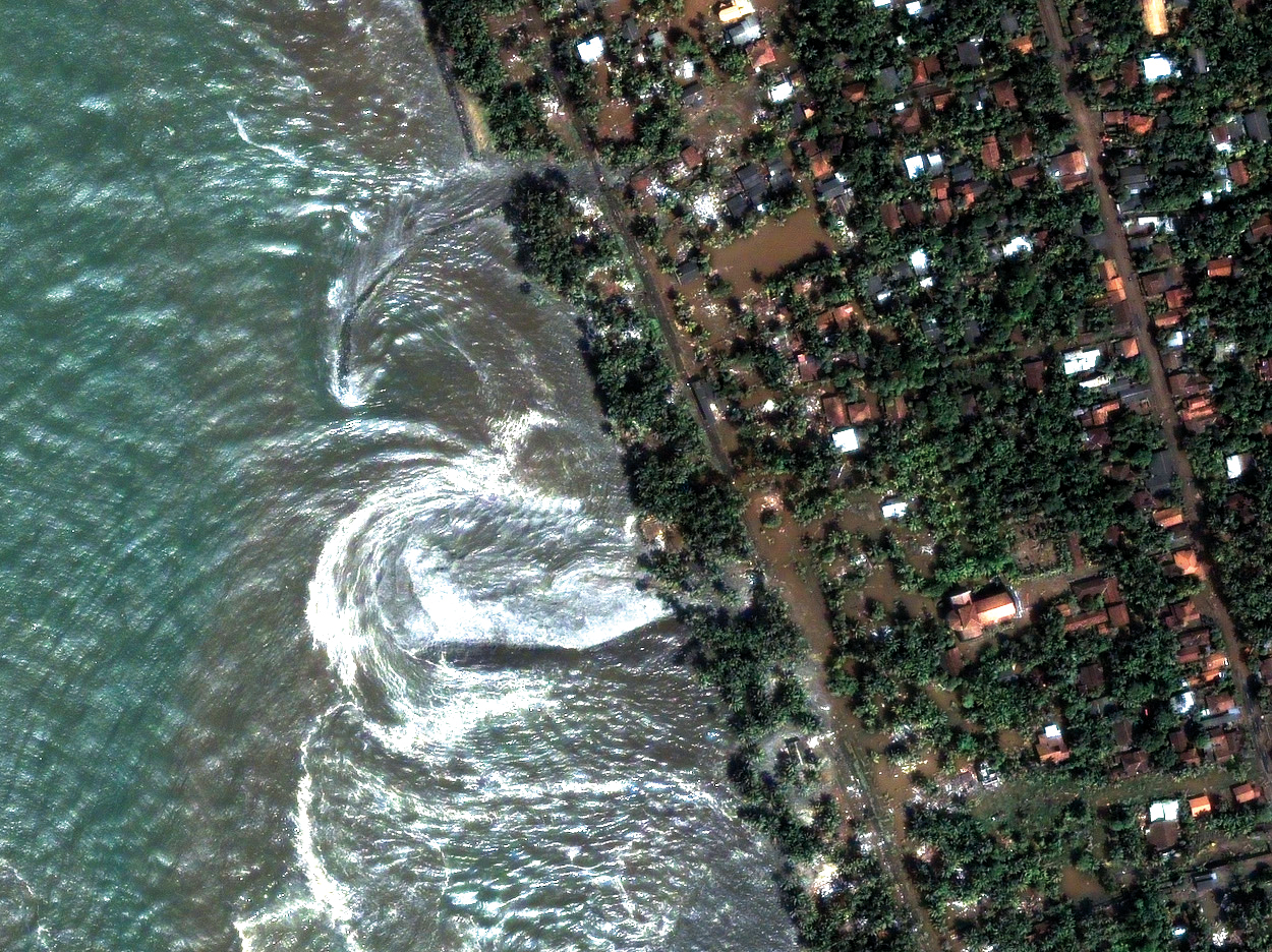
EddyBy analogy with a molecule, a “glob” of fluid within the fluid mass that has a certain integrity and life history of its own; the activities of the bulk fluid being the net result of the motion of the eddies.
Eddies generated by the interactions of tsunami waves as they hit the coast of Sri Lanka, 26 December 2004. Photo courtesy of Digital Globe. | |
Elapsed timeTime between the maximum level arrival time and the arrival time of the first wave. | |