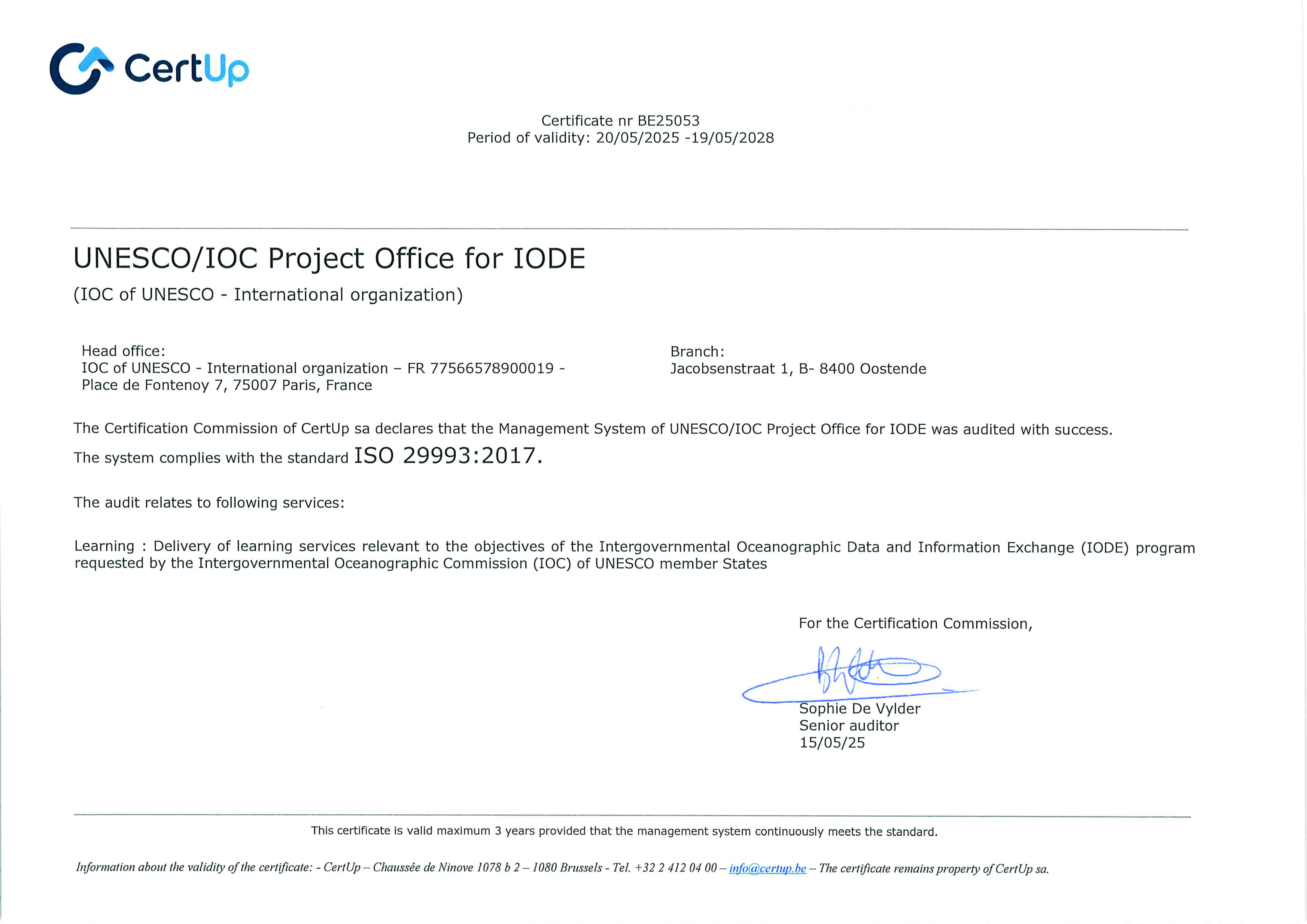
Network of OTGA Regional and Specialized Training Centres

For an overview of the planned course calendar please check the IOC/OTGA calendar

1

What is the OceanTeacher Global Academy

The OTGA e-learning platform offers online training on a wide range of topics related to ocean science.

2

Understand how the OTGA Platform works

This video describes how to register on the OceanTeacher e-Learning Platform and have access to selected courses,

The OceanTeacher Global Academy (OTGA) has established a global network of Regional and Specialised Training Centres (RTCs & STCs) to deliver customised training for ocean experts and professionals to increase national and regional capacity in coastal and marine sciences, services and management.

    Site news

    IOC/OTGA/OIH: Implementing the Ocean Data and Information System (ODIS) architecture [SELF PACED]

    by Sofie de Baenst -

    In case you missed the Ocean InfoHub training in April 2023. The course is now available in a 100 % self - paced format in 4 different languages: Spanish, French, Portuguese and English. All the info on this course and how to enrol is available here: https://oceanexpert.org/event/3921

    This course is available until 1st September 2023.

    NEW COURSE: Ocean Model Configuration for OFS Implementation - online

    by Sofie de Baenst -

    Course description:

    Ocean model is a representation of a numerical mathematical equation of the ocean and its interaction with atmosphere and land. The ocean model in the Maritime Continent aims to capture the complex interaction between ocean and atmosphere in this region, therefore configuring an ocean model for a certain area needs to specify specific domain, type of the equation and numerical methods used, the parameterization of subgrid scale processes and Forcing data used to drive the model, such as atmospheric data and boundary condition. 

    One of the most commonly used ocean models is the three-dimensional numerical model, which divides the ocean into a grid of cells and uses mathematical equations to simulate the physical processes within each cell. The model is initialized by ocean currents, temperature, and salinity data, and other variables, and run over a period of time, typically several years, to simulate the evolution of the ocean under different conditions.

    Among those models existed, BMKG had developed the BMKG Ocean Forecast System (BMKG-OFS) as one of Meteo-Oceanography modeling systems used to support prediction and information about waves, ocean currents, salinity and sea temperature for the communities. Development of BMKG OFS is an attempt to fulfill community needs in various sectors such as sea transportations, fisheries, mining and energy, marine-related activities. 

    BMKG OFS consists of 3 primary components: Ocean Wave Model, Ocean Circulation Model, and Drifting model. Ocean Wave Model named  Ina-Waves  used to support sea waves information. Ocean Circulation Model named  Ina-Flows , used to support current, salinity and sea temperature information at every depth. The drifting model is used to support object trajectory, sea level and coastal flood information.

    This training will provide participants with a basic knowledge on ocean modeling in terms of marine warning and forecast. The way that ocean numerical modeling systems developed by BMKG support operational analysis and forecast of ocean parameters (waves, ocean currents, sea temperature, salinity, and sea water level) will also be discussed. The processing and visualization met-ocean data set from BMKG-OFS using open source applications will be discussed briefly as supporting tool for data observation in the provision of marine meteorology services. 

    The course will run from 26 June - 8 July 2023.

    Apply until 09 June 2023

    Info: https://oceanexpert.org/event/3919


    IOC/OTGA/STC Argentina: Observador de Hielo Marino y Témpanos [virtual]

    by Sofie de Baenst -

    Las observaciones de hielo marino y témpanos son una fuente de información sobre lugares remotos como las regiones polares y son de gran utilidad para la cartografía de hielo y la validación de estudios climáticos.

    Este curso está diseñado para certificar la capacidad de los observadores en aguas polares. Desde el proceso de formación del hielo marino hasta la realización de observaciones desde buques o estaciones utilizando el Sistema de Información Glaciología (SIGLAC).  Además, se darán los conocimientos para la interpretación de cartas de hielo y otras herramientas para usos operativos

    más información : https://oceanexpert.org/event/3909
    Periodo de aplicación al curso: 1-22 mayo 2023
    Periode el curso: 12-16 Junio 2023

    Older topics...